
Marine debris is a familiar sight on shorelines around the world, and a reminder that there is still work to be done to tackle this global environmental problem. While we know a lot about marine debris, there are questions that can help test and identify the best solutions. How much marine debris is on our shores? What kind of debris is it, and where does it come from? Are these things changing over time? You can help find the answers through NOAA’s Marine Debris Program Monitoring and Assessment Project! An updated Monitoring Toolbox contains all of the resources you need to get started.
Through the NOAA Marine Debris Monitoring and Assessment Project, or MDMAP, our partners and volunteers around the world survey and record the amount and types of marine debris on shorelines. The Monitoring Toolbox is the one-stop shop for getting oriented to MDMAP. Based on input from participants and users of the data, we recently updated the entire Toolbox. Check it out:
- Training videos in English and Spanish that walk you through each step, from choosing the right site all the way through learning how to categorize and record your data in the MDMAP database
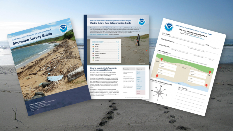
- A Shoreline Survey Guide with written instructions and diagrams on how to conduct a survey and collect important information
- A Marine Debris Item Categorization Guide, which describes how to count and categorize marine debris with photo examples
- Field datasheets, which include a quick guide to conducting a survey
- Examples of publications and projects that have used MDMAP data
- An open access MDMAP Database for data entry, exploration, and retrieval
- And more!
.")
.")
.")
If you’re curious about what others have already found, visit the MDMAP open access database. New interactive data visualizations allow you to explore results and see the amounts and kinds of debris reported. View the data in different ways using filters, select from a site or set of sites, and download it using the export button. Your site can be part of this important public dataset!
.")
.")
.")
.")
.")
Interested in joining this growing network? Watch the introduction video below and other video tutorials to get started surveying a shoreline near you. At any point, reach out to project staff at md.monitoring@noaa.gov with questions. See you on the shore!